Part of: Lesson Plans (46 resources )


 of bulging eyes with defined upper lids, long, straight, triangular nose, symmetrical scarification patterns consisting of three horizontal lines on each cheek, and a short beard from ear to ear just underneath the lower lip. Two large “ears” protrude on either side of head and act as “scaffolding” for numerous attachments of symbolic content: birds and lions predominate, but also visible are amulets, wooden claws and beads, crosses, and an insignia shield of some kind. The ears terminate in two oblong mirrors with lions leaping off of each. Layers of pigment are visible, giving the impression that it has been repainted over time.")


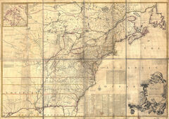


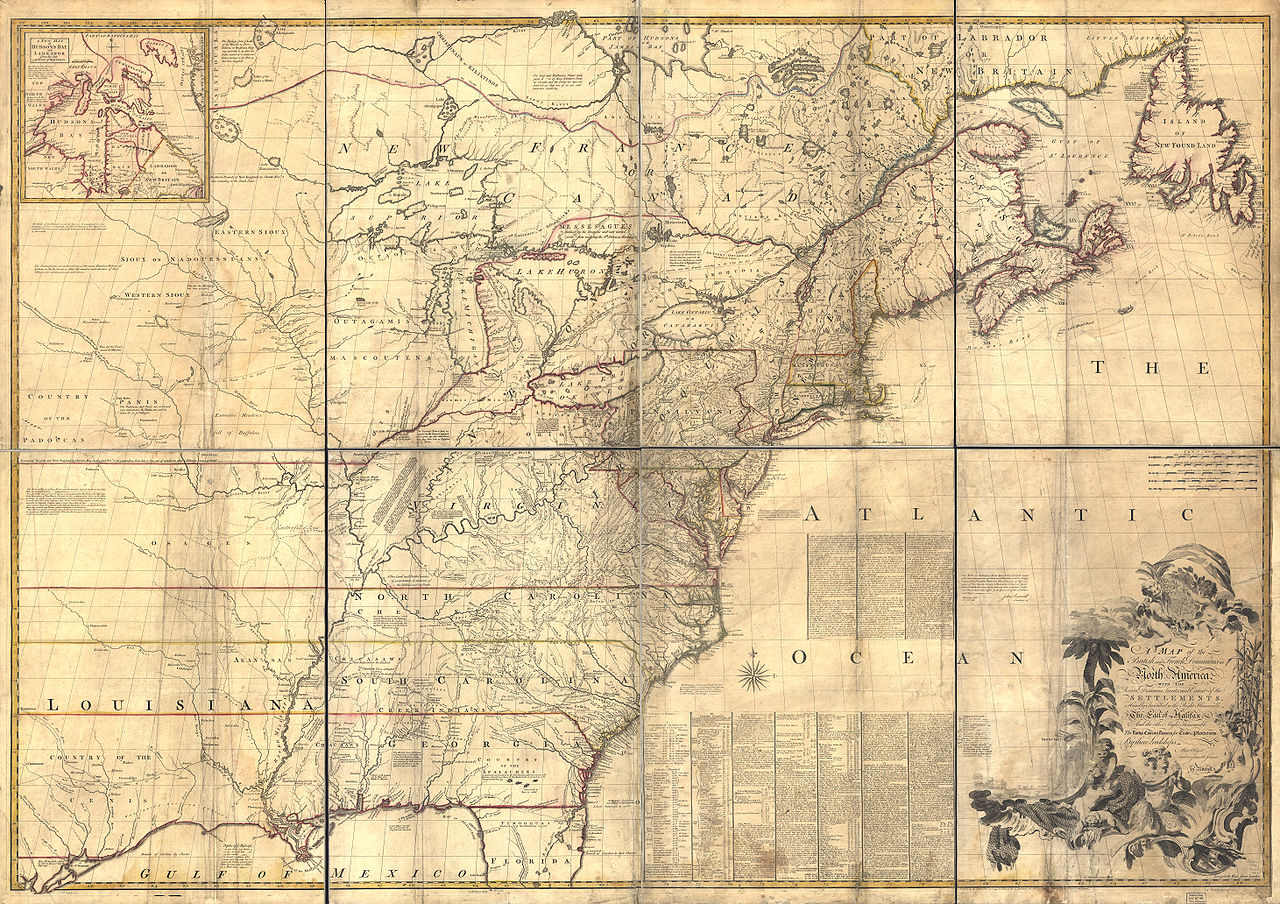
Lesson Plan: Memory Maps, Using the Mitchell Map (1755)
“Benjamin West: General Wolfe and the Art of Empire” UMMA Teacher Workshop, October 17, 2013

Objectives
Students will decipher maps and map keys. Students will discuss cartographers’ subjectivity and selectivity when creating maps.
National Core Art Standards
- Convey meaning through the presentation of artistic work
- Interpret intent and meaning in artistic work
- Synthesize and relate knowledge and personal experiences to make art
Michigan Social Studies Standards
- Distinguish between physical and human characteristics of places
- Construct maps of the local community that contain symbols, labels, and legends denoting human and natural characteristics of place
Grades
2-5
Time Required
One 45-minute class period
Materials
- Floorplans of your classroom, school, or playground, enlarged and divided into numbered, rectangular 3x5” sections.
- Unlined 3x5” note cards
- Colored pencils and pencils
Lesson
- To prepare for teaching, read the attached background article on the Mitchell Map
- Show students the slide of the Mitchell map. Explain that the cartographer made this map by using information from a number of earlier maps of smaller geographic areas. He looked at them and ascertained how they would fit together and then drew the large map—a compilation of information. Tell them about the notes written on the map and read some of them from the article.
- Show your students the plan of your room, school, or playground. Discuss it so they understand what it represents. Use the key to decipher the map.
- Have each child select a section from this large plan. Tell them to select a section that they know well or from which they might have a vivid memory. Several students may select the same section. Ask students to close their eyes and imagine what their section looks like. You may do some visualization, guiding them to think about the landscape, the structures, experiences they may have had there. When the students open their eyes, ask them to draw their vision with the colored pencils on a 3x5 card. When finished have them add a sentence to the card describing their image.
- When everyone is finished, affix the children’s cards to the plan. Discuss the different perspectives shown, the different stories that might come out, and speculate about why some areas are empty or "unexplored." Look at the Mitchell Map again and discuss with the students, while the new experience of making a map together is in their minds. This time, especially note incomplete or speculative knowledge of sections of the whole.
The Mitchell Map, 1755-1782: An Irony of Empire
- Introduction and Overview
The Mitchell Map has been described, and rightly so, as the most important map in North American history. The most comprehensive map of North America produced during the Colonial Era, it represented the various territorial claims made not only by the competing British and French empires but also by the various British colonies. It has accordingly served, as recently as 1932, in legal disputes between eastern states. More importantly, it was the map on which the boundaries of the new United States were defined by American and British negotiators in Paris in 1782-83; in that capacity, it has continued to be of importance right up to the 1980s US-Canadian dispute over the Gulf of Maine fisheries.
The map donated to the Osher Map Library is therefore a doubly important historical document. It is, in its own right, a map of great significance for American history. It is, furthermore, one of only three known to exist world-wide which have been annotated with eighteenth-century treaty lines, including the "red line" of the U.S. boundary.
John Mitchell, his Political Vision, and his Map
The size of the Mitchell Map -- about 6½ feet wide by 4½ feet high -- and its great detail might lead the reader to think that its maker was an accomplished map-maker. However John Mitchell had no prior mapping experience. Born in Lancaster County, Virginia, in 1711, Mitchell studied medicine at the University of Edinburgh, Scotland. Practicing medicine back in Virginia, he spent his spare time examining the local flora. A serious illness forced him to return to England in 1746. Once recovered, his interests increasingly turned to publicizing the French threat to the British colonies.
By 1746, North America was a stage set for an imperial struggle. The British and the French both claimed substantial areas of the lands east of the Mississippi and north of Spanish Florida. The Treaty of Utrecht (1713-14) had brought an end to a global war between the two powers, whose colonial campaigns are known as Queen Anne's War. A significant portion of the treaty had clarified and defined the boundaries between the territories claimed by the two nations in North America. Thirty-five years later, however, British colonists were increasingly convinced that the treaty had failed: the French were encroaching on British territory.
It was in this context that Mitchell made his map. His purpose was to present to the British public an image of all of the colonies so that the true scale and extent of the French threat could be exposed. He completed his first draft in 1750. Because it was based only on the publicly available sources of information, this first map was rather crude, even in Mitchell's own opinion. But word of Mitchell's work spread through elite London society. The Board of Trade and Plantations, the government agency with responsibility for the colonies, retained Mitchell to make a new map using the official maps and reports in the Board's possession. The Board also sent instructions to the colonial governors requiring them to send detailed maps and boundary information back to London for Mitchell's use.
Andrew Millar published Mitchell's map in 1755, the year before war broke out with the French. In addition to the geographical outline of the continent and the European colonies, Mitchell also included many textual legends describing the extent of British and French settlements. Mitchell always gave the benefit of any doubt to the British claims. He also submitted a report to the Board in 1752, listing the French encroachments and suggesting new strategies to encourage British settlement between the Appalachians and the Mississippi in order to counteract the growing French influence. Mitchell is usually credited with authorship of an anonymous tract published in London, The Contest in America Between Great Britain and France by an Impartial Hand (1756), which again voiced concern with French expansion.
The first edition of the map was entitled A Map of the British and French Dominions in North America ..., and bore the copyright date of February 13th, 1755. Shortly thereafter, Mitchell produced a second edition, probably in 1757. In addition to a few changes in geographical detail, this edition had two large blocks of text added in the middle of the Atlantic. The text is Mitchell's own account both of his data sources and of how he compiled the numerous provincial maps into the bigger frame of North America. After Mitchell's death in 1768, the printing plates were acquired by the cartographic publishers, "Jefferys and Faden." Some geographic details were updated and a third edition was printed in 1773-74. Finally, in 1775, Faden published a fourth edition under a new title that reflected the British defeat of the French and the annexation of Québec: A Map of the British Colonies in North America ....
An Irony of Empire: Mitchell's Map and the Treaty of Paris
When British and American negotiators met in Paris in 1782 to draft a peace treaty to end the Revolutionary War, an issue of central importance was clearly that of the boundaries of the fledgling United States. There were three major configurations of the boundary lines proposed by either side; the third, proposed by the British negotiator Richard Oswald, was accepted by both sides in November 1782 and was written into the final treaty of September 3rd, 1783. Thus, Maine's eastern boundary was defined "by a line to be drawn along the middle of the river St. Croix, from its mouth ... to its source, and from its source directly north to the ... Highlands, which divide the rivers that fall into the Atlantic Ocean from those which fall into the river St. Lawrence." Despite the importance of the issue, no map of the boundaries was attached to the treaty. Without graphic explication, the textual definition was wide open to interpretation. In the case of Maine's eastern boundary, the British and Americans would soon disagree as to what river is actually the St. Croix.
A map was however used in the actual negotiations to trace out the boundaries: Mitchell's Map. It is ironic that a map intended to proclaim the British control of North America was used in the dismemberment of British colonial power.
John Jay, on the American delegation, used a third edition of the map. His map, today in the New York Historical Society, marks his understanding of the boundary. For example, Jay had the eastern Maine border running along the St. John river, well inside modern New Brunswick.
Oswald and the British used a copy of the fourth edition of Mitchell's map. The British arguments as to the proper boundary for the United States were rooted in the territorial limits established by earlier treaties between Great Britain and France. Oswald marked all of these limits onto his map: Nova Scotia, British fishing limit, and conflicting British and French interpretations of the interior boundaries, all by the Treaty of Utrecht; the boundaries of the Hudson's Bay Company; the boundaries of Québec defined in 1763 and 1774; and, the 1763 Proclamation Line that separated British settlement from the Indian Lands. To these he also added a thin red line, in ink rather than watercolor, for the British interpretation of the new U.S. boundary. After the treaty was concluded, Oswald gave this map to King George III; it is now in the British Library. The king himself labeled the red line in ten places as "Boundary as described by Mr. Oswald." For this reason, this map is usually referred to as the "red line" map. This map is thus a statement of the British vision of North American territories.
Note: The content of this web document has been significantly updated, corrected, and expanded by two publications:
Edney, Matthew H. “A Publishing History of John Mitchell’s 1755 Map of North America.” Cartographic Perspectives, no.58 (2007): 4-27 and 71-75.
Edney, Matthew H. “John Mitchell’s Map of North America (1755): A Study of the Use and Publication of Official Maps in Eighteenth-Century Britain.” Imago Mundi 60, no.1 (2008): 63-85.
Acknowledgments
Dr. Stephanie Abbot Roper was of great help in clarifying the political aspects of the map. Dr. Ronald Grim, Geography and Map Division, Library of Congress, Dr. Andrew Cook, Oriental and India Office Collections, British Library, and Mr. Edward Dahl, Early Map Specialist, National Archives of Canada were of great assistance in liberally sharing their knowledge of the "Red Line Map," its copies, and War Office draftsmen. Ms. Wendy Raver, New York Historical Society, kindly interrogated John Jay's map over the telephone at very short notice. General assistance provided by Dr. Harold L. Osher; Yolanda I. Theunissen, Curator and Head of Cartographic Collections; and Christi A. Mitchell, Cartographic Associate, Osher Map Library. Abraham Schechter, photographic conservator, Portland Photographics, took the photographs from which most of the imagery was scanned. Some imagery is provided courtesy of Skinners, Auctioneers and Appraisers of Antiques and Fine Art, Boston and Bolton, Massachusetts; for more information call (508) 779-6241 x 228. Publicity provided by Robert S. Caswell, Director, and Susan E. Swain, Associate Director, Media & Community Relations.
Part of 1 Learning Collection
“Tradition Transformed: Chang Ku-nien Master Painte...
“Creative Literacies: Expanding our View,” UMMA Wor...
UMMA Exhibition, “The Graphic Dimension: Prints and...
“Creative Literacies: Expanding our View,” UMMA Wor...
“Teaching with Photography,” UMMA Workshop for Educ...
“Creative Literacies: Expanding our View,” UMMA Wor...
Lesson adapted from Educator Resources, Victoria & ...
“Benjamin West: General Wolfe and the Art of Empire...
“Creative Literacies: Expanding our View,” UMMA Wor...
“Teaching with Photography” UMMA Teacher Workshop,...
Lesson inspired by Elaine Wilson’s “Charting the Wo...
“Tradition Transformed: Chang Ku-nien Master Painte...
UMMA Teacher Workshop, “Xu Weixin: Monumental Portr...
“Teaching with Photography,” UMMA Workshop for Educ...
“Teaching with Landscape Photography,” UMMA Teacher...
UMMA Teacher Workshop, “Xu Weixin: Monumental Portr...
“Creative Literacies: Expanding our View,” UMMA Wor...
2 Links
Rate this Resource
AVG: 0 | Ratings: 0
& Author Notes
Creative Commons by-nc-saLast Updated
March 6, 2017 1:19 a.m.Report
Reporting Policy
